大暑(國曆7月22或23或24日)

視頻:
大暑,一年當中天氣最熱的時候,果真如此啊。近期,美國南部幾個州屬,都被熱浪襲擊,從 7 月初開始,我們住的北德州,氣溫幾乎天天過百(華氏)。天啊!每天出門,猶如走進莫大烤箱,太陽曬下來刺刺、烘烘的,連呼吸也有點不順暢。
07.27.2023 下午 4 點,氣溫仍高,
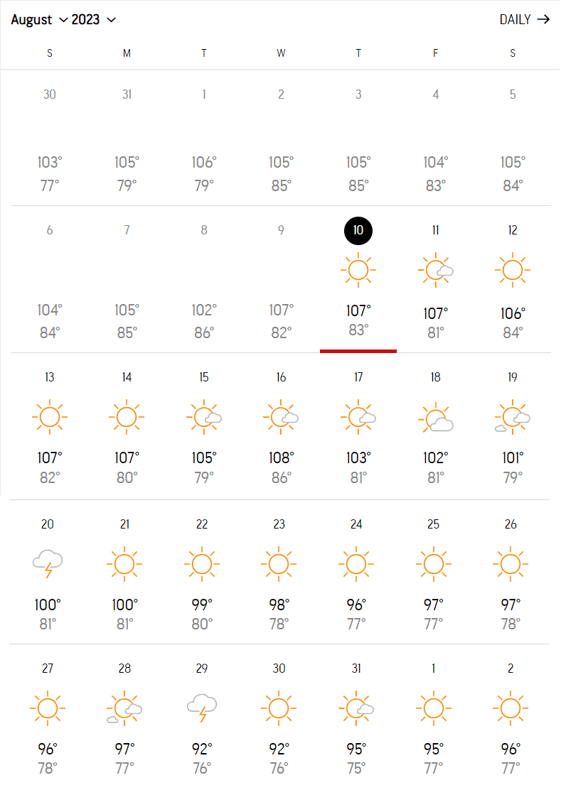
接下來 10 天的天氣預報,天天都超過三位數。
果然是名符其實的 ‘大暑’!

我們住的北德州,小暑的 16 日裏有 9 日超過華氏 100 度。
大暑的 16 日裏,有 15 天超過華氏 100 度。(哇!將鷄蛋移至戶外搞不好真的會熟!)
真是酷熱啊!比較以前住過的南德州 -- 休斯頓,北德州更加酷熱。
爲什麽呢???
When a heat dome settles into a location, it takes a big push from the jet stream or another relatively strong system higher up in the atmosphere to dislodge it.
It’s excruciatingly hot in North Texas, and a weather phenomenon called a “heat dome” is to blame.
A heat dome has hovered over a massive part of the country creating dangerous temperatures in Texas, Oklahoma and Louisiana — and expanding as far as Arkansas, Kansas, Missouri, Mississippi and Florida in recent days. (7/4 的 long weekend,原本想帶家人到 Arkansas 避暑的,沒想到 Arkansas 也被熱浪襲擊,午後仍是艷陽高照,暑氣逼人)
“The reason why we’re having all this is heat is an area of high pressure directly over the central and southern United States,” Allison Prater, a meteorologist with the National Weather Service in Fort Worth, told The Dallas Morning News. “There’s been quite a bit of heat going out, and when we have that high pressure we have sinking air — so warming temperatures, not a lot of clouds and no rain chances.”
A trough — an elongated area of relatively low pressure — on the West Coast could make its way east to Texas in the latter half of the week and take the high pressure hovering over our region with it, Prater said.
“It looks like as that moves across the region into the Central Plains and toward the east that it’s going to break down the ridge of high pressure, giving us some lower temperatures,” she said. “It’s still going to be hot, but not nearly as hot as what we’ve been seeing.”(哎呀!原來熱氣慢慢往東移,北德州 7/1 那個周末的氣溫竟比 Arkansas 還低,選擇到 Arkansas 避暑好像沒這麽理想,應該留在北德州才對啊!哭!哭!對氣象不瞭解就會出現這種狀況!)
Those lower temperatures will be evident this weekend and early next week as chances for isolated storms in North Texas also increase. Heat indices will remain high, though, Prater said, so it’s important to continue practicing heat safety.

What is a heat dome「熱蓋現象」?
Record high temperatures — or very hot heat waves — can happen because of a heat dome that parks itself over a specific spot, according to AccuWeather.
A heat dome occurs when a high-pressure system is “stuck” in a certain location and holds the heat in. The atmosphere acts like a lid or cap over a region and traps in the hot ocean air, according to the National Oceanic and Atmospheric Administration.

Heat domes usually are linked to the behavior of the jet stream, a band of fast-moving atmospheric winds that generally flow west to east, William Gallus, professor of atmospheric science at Iowa State University, wrote for CBS News. (資料來源:The Dallas Morning News)
~ 以下資料取自 2021 年 7 月 2 日 BBC News 中文:~
為什麼發生極端高溫?
連續多日的極端高溫是所謂的「熱蓋現象」(heat dome)所造成的結果,過去兩周以來滯留這片地區上空的阻塞高氣壓導致大量熱空氣生成,熱空氣出不去又被高氣壓向下壓縮後變得更熱。

由於熱空氣會往上升,然後又被上方的阻塞高氣壓往下推,被壓縮後到達地面,地表氣溫就變得更熱。
專家表示,氣候變化預料將增加這種極端天氣的發生頻率,但是這次的單一事件也不能如此簡單地全部歸咎於全球變暖。
參考資料:
No comments:
Post a Comment